 Xiaohongshu
 ORCID
ORCID
Hi! I am Kaizhen Tan, a Ph.D. student at New York University, supervised by Prof. Chenghe Guan and Prof. Zhan Guo. I received my master’s degree in Artificial Intelligence at Carnegie Mellon University and bachelor’s degree in Information Systems from Tongji University.
My research sits at the intersection of Urban Science and Embodied AI. Driven by the vision of harmonizing artificial intelligence with urban ecosystems, I aim to address the knowledge-to-action gap in digital cities: while urban digital systems are increasingly capable of monitoring conditions, modeling urban dynamics, and anticipating risks, they still struggle to support timely, place-based action. My work seeks to build spatially intelligent and socially aware urban AI systems that make cities more adaptive, inclusive, and governable.
My research integrates:
- Paradigms: Robotic Urbanization, Agentic Urban Digital Twins, Multimodal Social Sensing, Spatial Intelligence
- Methodologies: Representation Learning, Geospatial & Spatiotemporal Data Analysis, Agent-Based Simulation
- Technical Foundations: LLMs, VLMs, AI Agents, World Models
Specifically, my research agenda is organized around four key topics:
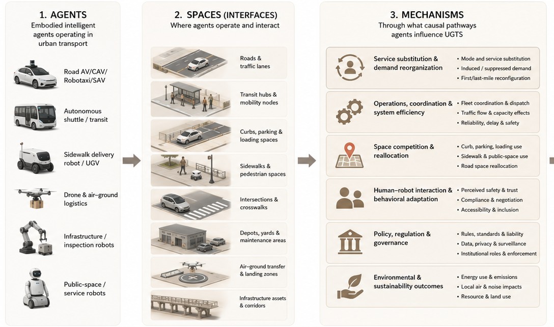
🤖 1. Robotic Urbanization & Governance
How can dense cities integrate embodied intelligence while preserving safety, accessibility, and pedestrian experience?
- Urban Readiness for Robots: Measure whether sidewalks, crossings, curbs, buildings, and public facilities can support safe robot operation.
- Human-Robot Coexistence: Study conflicts, comfort, right-of-way, and interaction norms between robots, pedestrians, cyclists, and vulnerable groups.
- Accessibility-Aware Deployment: Design routing and operation strategies that avoid reducing mobility for disabled people, older adults, and children.
- Curbside and Low-Altitude Governance: Develop spatial rules for delivery robots and drones, including lanes, parking, corridors, privacy, noise, and safety constraints.
- Public Acceptance and Accountability: Model public perception, responsibility boundaries, and governance mechanisms for city-scale deployment.
🏙️ 2. Agentic Urban Digital Twins
How can urban digital twins evolve from static city models into continuously updated systems for sensing, reasoning, and policy support?
- Urban Foundation Representations: Fuse remote sensing, street-view imagery, trajectories, POI, IoT, text, and 3D data into unified urban representations.
- Continuous Urban Sensing: Use robots, drones, mobile devices, and wearables as emerging data sources to update urban conditions over time.
- 3D City Understanding: Support geo-localization, semantic mapping, and spatial querying across point clouds, meshes, and 3D Gaussians.
- Urban Agents: Build LLM and VLM agents for map reasoning, spatial RAG, policy QA, public service assistance, and planning workflows.
- Policy Sandbox: Enable what-if simulation, risk assessment, and implementation checks for urban management and public policy.
🎨 3. Multimodal Social Sensing
How can multimodal human-centered data reveal urban experience, social needs, and governance priorities?
- AI-Enhanced Geospatial Analysis: Link urban form, environment, mobility, and public services with human behavior and social outcomes.
- Pedestrian Experience and Accessibility: Detect walking barriers, sidewalk quality, perceived safety, and mobility challenges in everyday urban environments.
- Urban Perception and Visual Aesthetics: Quantify streetscape quality, neighborhood imagery, and place identity to support design and regeneration decisions.
- Socio-Cultural Signals: Extract place-based narratives from text, images, and online platforms to understand local identity and public concerns.
- Participatory Governance: Translate social sensing results into explainable tools for planners, communities, and decision-makers.
🚀 4. Spatial Intelligence & World Models
How can spatial intelligence provide reliable reasoning, memory, and simulation capabilities for urban AI systems?
- Embodied Spatial Representations: Unify geometry, semantics, physics, affordance, and action for robots, agents, and urban digital twins.
- Urban World Models: Learn predictive models of how urban spaces change and how agents interact with physical and social environments.
- Spatial Reasoning with VLMs: Improve map understanding, 3D reasoning, scene interpretation, and location-aware decision-making.
- Lifelong Updating and Memory: Develop mechanisms for continuous learning, forgetting control, uncertainty tracking, and safe model updates.
- Interpretable and Robust Decision Support: Make spatial AI systems transparent enough for planning, governance, and real-world deployment.
🔥 News
- 2026.07: 🎉 Our paper CREG was accepted by the 9th Chinese Conference on Pattern Recognition and Computer Vision (PRCV 2026).
- 2026.03: 🎓 I am pleased to share that I will begin my PhD at New York University in Fall 2026 under the supervision of Prof. Chenghe Guan and Prof. Zhan Guo.
- 2026.01: 🎉 The abstract co-authored with Prof. Fan Zhang has been accepted for the XXV ISPRS Congress 2026. See you in Toronto!
- 2025.12: 🎉 Our paper, led by my senior labmate Dr. Weihua Huan and co-authored with Prof. Wei Huang at Tongji University, was accepted by GIScience & Remote Sensing; honored to contribute as second author and big congratulations to Dr. Huan!
- 2025.10: 🔭 Joined Prof. Yu Liu and Prof. Fan Zhang’s team at Peking University as a remote research assistant.
- 2025.08: 🎉 Delivered an oral presentation at Hong Kong Polytechnic University after our paper was accepted to the Global Smart Cities Summit cum The 4th International Conference on Urban Informatics (GSCS & ICUI 2025).
- 2024.04: 🔭 Began my academic journey at Prof. Wei Huang’s lab in the College of Surveying and Geo-Informatics, Tongji University.
📖 Education
💼 Experience
🔭 Research
💻 Industry
📝 Publications
Peer-Reviewed
Preprints & Under Review
In Preparation
Technical Reports
No publications in this direction yet.
💬 Presentations
-
2026.07 - XXV ISPRS Congress 2026
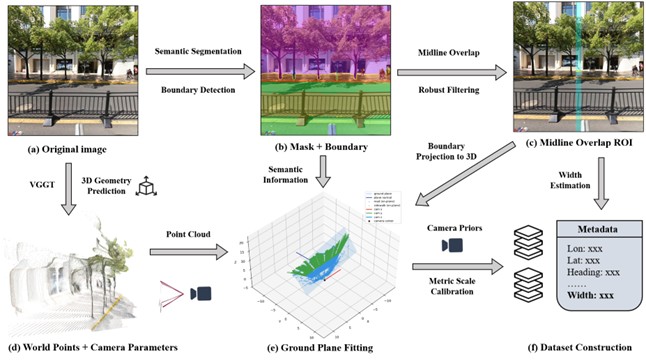
UrbanVGGT: Scalable Sidewalk Width Estimation from Street View Images
Toronto, Canada -
2025.08 - Global Smart Cities Summit cum The 4th International Conference on Urban Informatics (GSCS & ICUI 2025)
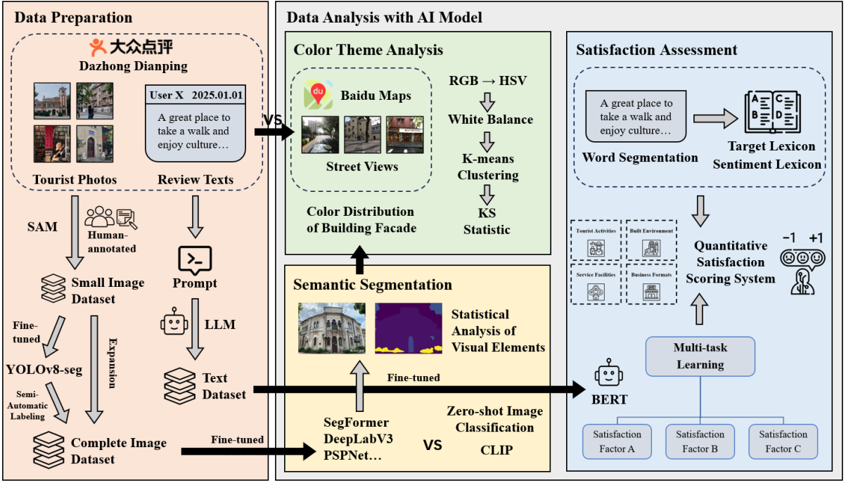
Decoding Tourist Perception in Historic Urban Quarters with Multimodal Social Media Data: An AI-Based Framework and Evidence from Shanghai
Hong Kong Polytechnic University (PolyU), Hong Kong SAR, China -
2025.07 - 7th Asia Conference on Machine Learning and Computing (ACMLC 2025)
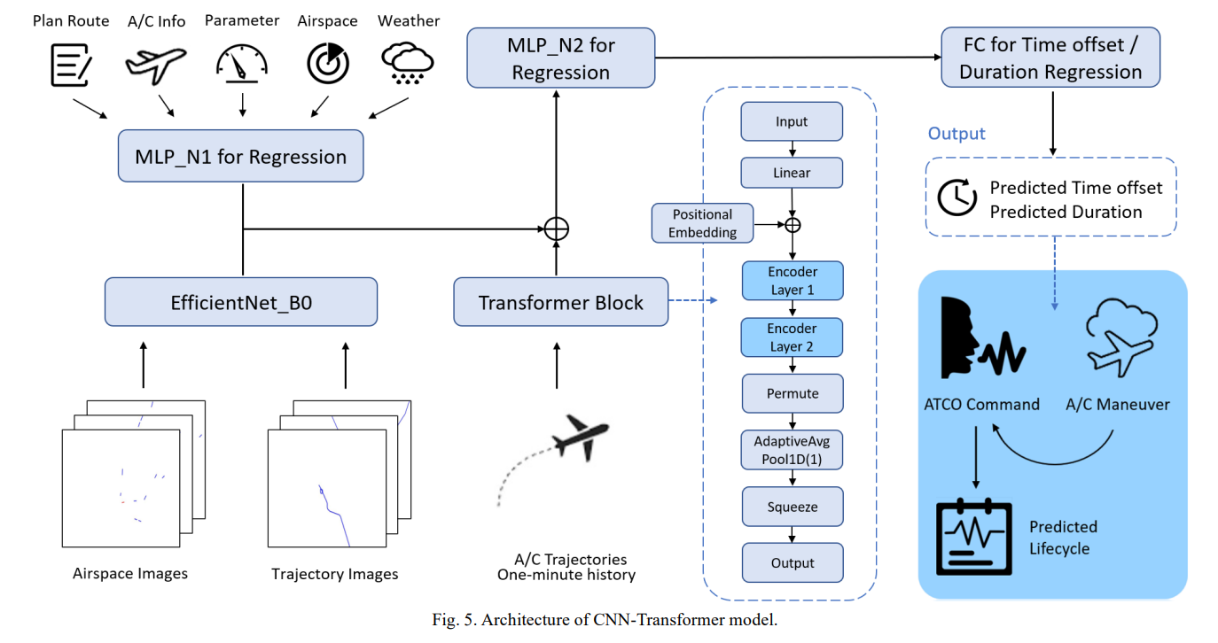
Multimodal Deep Learning for ATCO Command Lifecycle Modeling and Workload Prediction
Hong Kong SAR, China
📫 Contact
- Email(NYU): kt3275@nyu.edu
- Email(CMU): kaizhent@cmu.edu
Please feel free to reach out if any of these research directions resonate with you. I'd be happy to chat!